Perusahaan ini terdaftar sebagai Free Member. Hindari melakukan pembayaran sebelum bertemu penjual atau melihat barang secara langsung. COD (Cash On Delivery) atau bertemu langsung dengan penjual merupakan metode transaksi aman yang kami sarankan.
The MPH Advantage™ geographic information system ( GIS) is used to capture, store, manage, retrieve, analyze, and display spatial information. GIS information is geo-referenced to the coordinates of a particular projection system. This allows precise placement of features on the earth’s surface and maintains the spatial relationships between mapped features.
GIS systems measure any GPS position or whole area faster than traditional methods, keeping your costs down and performance up. The Advantage GIS System makes fast work of GPS mapping, letting you collect offsets and inaccessible points easily.
Private Property
Obtain GPS or site readings from a remote location.
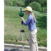
Small Crew
Single-operator system for any mapping operation.
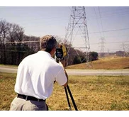
Map Large Areas
Handles any measurement 2,000 feet away – 30,000 feet with prisms.
This GIS system can be positioned at convenient reference point, and one operator can map almost any visible point, even under canopy. Bearing and range data can be provided to obtain GPS placements of structures like buildings, bridge footings, or roads.
Easy and Complete
Head up display, on-site mapping or data capture.
Measure any Attribute
Maps a location’s size, elevation and land features.
Flexible Accuracy
Handheld, monopole or extreme-precision Encoding Tripod.
Plug & Play Compatible
Use existing GPS receivers, GIS and CAD systems.